
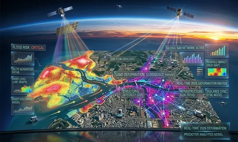
In 2026, the global capacity for disaster resilience has been fundamentally transformed by the operational maturity of Synthetic Aperture Radar (SAR) constellations. Unlike traditional optical satellites that are blinded by the very storm clouds that cause disasters, SAR “sees” through atmospheric interference to provide high-resolution data in all weather conditions. By leveraging the unique dual-band capabilities of the NASA-ISRO SAR (NISAR) mission alongside the consistent archives of Sentinel-1, geospatial analysts can now map floods in real-time and detect millimeter-scale land deformations before they manifest as catastrophic failures.
The All-Weather Sentinel
The primary limitation of traditional Earth observation has always been its reliance on visible light. During a major hurricane or monsoon, optical sensors are rendered useless by cloud cover precisely when data is most needed. Synthetic Aperture Radar (SAR) overcomes this by being an active sensor; it emits its own microwave pulses and measures the “backscatter” that returns from the Earth’s surface.
As of early 2026, we have entered a “Golden Age” of radar. With NISAR providing consistent $L$-band ($24\ cm$ wavelength) and $S$-band ($12\ cm$) data, combined with the $C$-band ($5.6\ cm$) data from the ESA’s Sentinel-1, we possess a multi-layered diagnostic tool for the planet. This orbital vigilance allows us to monitor two of the most destructive geological and hydrological phenomena: flooding and land subsidence.
Flood Mapping: Penetrating the Storm
SAR is uniquely suited for flood detection due to the way microwaves interact with water.
- Surface Roughness & Backscatter: A calm water surface acts as a specular reflector. When the radar pulse hits standing water, it reflects away from the sensor, resulting in a low “backscatter” return. On a SAR image, flooded areas typically appear as stark, dark patches compared to the brighter, rougher texture of dry land.
- Double-Bounce Scattering: One of the most significant 2026 advancements is the use of SAR to detect “hidden” floods. In urban environments or forested wetlands, the radar pulse can bounce off the water surface and then off a vertical wall or tree trunk (a “double-bounce”), returning to the satellite with a distinct signature. This allows for accurate flood mapping even under dense forest canopies or within narrow “urban canyons.”
- Change Detection: By comparing a “post-event” image to a “pre-event” baseline stack, machine learning algorithms can automatically isolate new water bodies, filtering out permanent features like lakes or rivers to provide an instant map of inundation extent.
Land Deformation: The Millimeter-Scale Motion
While flood mapping uses the intensity of the radar return, monitoring land deformation relies on the phase of the radar wave. This technique is known as InSAR (Interferometric SAR).
By calculating the phase difference ($\Delta\phi$) between two radar passes over the same location, we can measure surface displacement ($\Delta r$) with sub-centimeter precision using the following relationship:
$$\Delta\phi = \frac{4\pi}{\lambda}\Delta r$$
Where $\lambda$ is the radar wavelength. In 2026, two advanced methods have become industry standards:
- PSInSAR (Persistent Scatterer): This identifies stable, highly reflective objects (like buildings or rock outcrops) to monitor long-term urban subsidence or infrastructure health.
- SBAS (Small Baseline Subset): This technique is optimized for monitoring deformation in more rural or vegetated areas by linking together image pairs with small temporal and spatial separations.
These methods allow engineers to detect $mm/year$ shifts in critical infrastructure, such as the gradual “swelling” of a volcano or the subtle “bowing” of a dam or levee before a breach occurs.
Data Fusion and Predictive Modeling
The power of SAR is multiplied when fused with other data streams. In 2026, we are seeing the integration of SAR-derived deformation maps with hydrological models. For example, if PSInSAR detects that a levee is subsiding at a rate of $15\ mm/year$, and a flood model predicts a 100-year storm event, authorities can prioritize that specific section for reinforcement.
Furthermore, Convolutional Neural Networks (CNNs) are now deployed at the “edge” on certain satellite clusters, allowing for automated, near-real-time extraction of flood boundaries, which are then transmitted directly to emergency responders’ mobile devices.
Case Study: The NISAR Impact
The 2024 launch and subsequent 2026 data-maturity of the NISAR mission have been a game-changer for land deformation. Because NISAR uses $L$-band radar, which has a longer wavelength ($24\ cm$), it can penetrate deeper into vegetation than $C$-band sensors. This has allowed for the first accurate deformation monitoring of tropical regions and heavily forested landslides, which were previously “invisible” to radar due to signal decorrelation caused by moving leaves. Its 12-day repeat cycle provides a consistent, global heartbeat of the Earth’s shifting crust.
Challenges and Future Outlook
Despite its power, SAR is not without challenges:
- Temporal Decorrelation: Significant changes in snow cover or rapid vegetation growth between satellite passes can “blur” the phase signal, making InSAR difficult in certain biomes.
- Data Volume: The sheer amount of data produced by NISAR and other constellations requires massive cloud-computing resources for processing.
The future lies in SmallSat SAR constellations, which are currently being deployed to provide sub-daily revisit times. This will move us from “monitoring” to “live-streaming” the Earth’s physical changes.
A Safer Earth from Orbit
Synthetic Aperture Radar has successfully transitioned from an experimental academic tool to a foundational pillar of global safety. By providing a clear view through the clouds and a millimeter-scale sense of touch from orbit, SAR technology ensures that we are no longer surprised by the Earth’s movements. In an era of climate volatility, this orbital vigilance is not just a technological luxury—it is a requirement for a resilient civilization.
SAR Band Comparison: X, C, and L-Band Applications
| Feature | X-Band (e.g., TerraSAR-X) | C-Band (e.g., Sentinel-1) | L-Band (e.g., NISAR / ALOS-2) |
| Wavelength ($\lambda$) | $\sim 3\ cm$ | $\sim 5.6\ cm$ | $\sim 24\ cm$ |
| Resolution | Highest (Sub-meter) | Moderate ($5–20\ m$) | Moderate ($10–30\ m$) |
| Penetration Depth | Low (Surface only) | Moderate (Top of canopy) | High (Through canopy to soil) |
| Primary Use Case | Infrastructure / Urban Monitoring | General Mapping / Flood Detection | Forestry / Deep Land Deformation |
| Sensitivity to Motion | Extreme ($< 1\ mm$) | High ($1–5\ mm$) | Moderate ($5–10\ mm$) |
