
The “High Seas” have traditionally lived up to their name as a lawless frontier, where the vastness of the ocean provided a veil for environmental negligence. In 2026, this veil has been pierced. The convergence of Synthetic Aperture Radar (SAR), high-revisit satellite constellations, and edge-based Computer Vision has created a global, transparent maritime monitoring system. By identifying “Dark Vessels” and attributing environmental damage in real-time, AI-powered orbital intelligence is transforming maritime law from a set of suggestions into an enforceable reality.
The Unseen High Seas
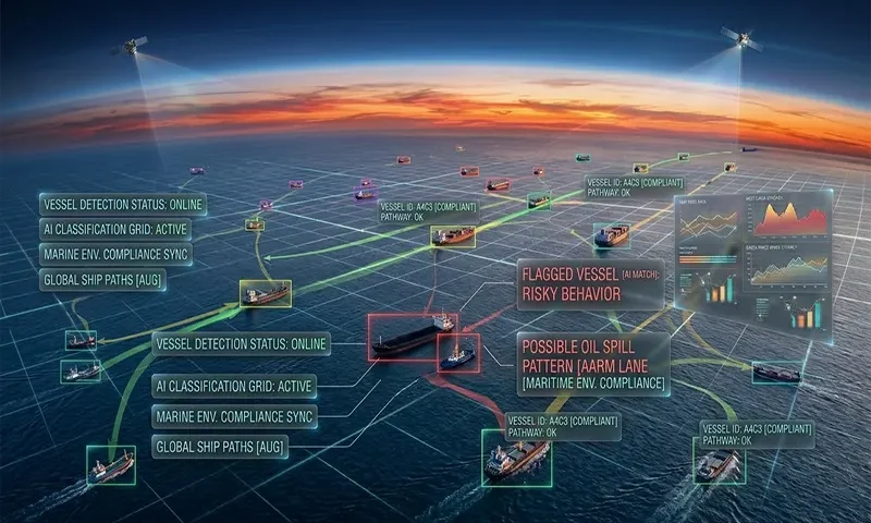
Monitoring the world’s oceans—covering over 70% of the Earth’s surface—has historically been an impossible task for physical patrols. The primary tool for maritime safety, the Automatic Identification System (AIS), relies on vessels voluntarily broadcasting their position. However, vessels engaged in illegal activity—known as “Dark Vessels”—simply turn off their transponders to vanish from digital maps.
As international regulations like MARPOL and the IMO 2030 decarbonization goals tighten, the need for independent verification is critical. In 2026, we no longer rely on a ship’s honesty. We rely on orbital observation.
The Multi-Sensor Orbital Stack
To ensure total maritime awareness, AI engines now fuse data from a diverse “stack” of sensors:
- Synthetic Aperture Radar (SAR): The cornerstone of vessel detection. Unlike optical cameras, SAR uses microwave pulses (typically in the $X$-band or $L$-band, ranging from $1\ GHz$ to $12\ GHz$) to penetrate cloud cover, smoke, and darkness. It detects the high-reflectivity of metallic hulls against the low-reflectivity of the moving ocean.
- Optical and Hyperspectral Imaging: Once a vessel is detected by radar, high-resolution optical satellites are used for classification (e.g., distinguishing a fishing trawler from an oil tanker). Hyperspectral sensors can detect the unique spectral “signature” of oil slicks or illegal $SO_x$ and $NO_x$ emissions plumes.
- VIIRS (Visible Infrared Imaging Radiometer Suite): Essential for detecting “Night Lights.” Illegal fishing vessels often use massive arrays of LED lights to lure squid and fish to the surface; VIIRS captures these light signatures from orbit, even when the vessel is dark on AIS.
The AI Inference Engine: Detecting the Invisible
The raw data from these satellites is massive. Manually scanning a $10,000\ km^2$ SAR image for a 50-meter boat is inefficient. 2026 systems utilize specialized AI to automate the hunt:
- Computer Vision at the Edge: Modern satellites now perform “In-Orbit Inference.” Convolutional Neural Networks (CNNs) scan the imagery as it is captured, flagging potential vessels and only transmitting the relevant “chips” (small image segments) to Earth. This bypasses the bandwidth bottleneck of sending entire high-res images.
- AIS-Satellite Correlation: The AI compares the “detected” vessels from satellite imagery with the “reported” vessels from AIS data. If the satellite sees a ship where no AIS signal exists, the system flags a “Dark Vessel Alert.” This anomaly detection is the primary tool for identifying illegal activity.
Enforcing Environmental Compliance
AI-powered detection is the “Smoking Gun” for several key environmental violations:
- IUU Fishing (Illegal, Unreported, and Unregulated): Satellites monitor Marine Protected Areas (MPAs). When AI identifies a dark vessel lingering in a “No-Take” zone with a trajectory typical of trawling, it creates a high-probability evidence package for authorities.
- Oil Spill Attribution: When a slick is detected, AI uses “Back-Trajectory Modeling.” By combining the satellite image of the slick with current, wind, and vessel traffic data from the preceding 48 hours, the system can mathematically prove which vessel discharged the oil.
- Emissions Monitoring: Modern spectrometers can detect the “scrubber” effluent and high-sulfur fuel signatures in a vessel’s wake, ensuring compliance with IMO 2020/2030 sulfur cap regulations ($SO_x < 0.5\%$).
Legal and Evidentiary Standards
In 2026, satellite data has crossed the threshold from “investigative lead” to “admissible evidence.” International maritime courts and insurance P&I clubs now accept AI-validated satellite reports as proof of presence or violation.
Organizations like Global Fishing Watch and OceanMind have pioneered “Transparent Oceans” models. By making this data public, they create a “Reputational Risk” that is often more effective than fines. No major shipping line or seafood distributor wants their brand associated with a vessel that has been “algorithmically shamed” for operating in a protected reef.
Challenges: Latency and Complexity
Despite the progress, two challenges remain:
- The Revisit Frequency Problem: A satellite might only pass over a specific point on the ocean every 6–12 hours. A fast vessel can travel $200\ km$ between passes. 2026 is seeing a surge in “SmallSat” constellations to bring “revisit times” down to under 30 minutes.
- False Positives: Distinguishing between a small wooden fishing boat (which reflects radar poorly) and a large wave crest requires highly tuned AI. Furthermore, offshore wind farms and oil rigs create “clutter” that AI must learn to ignore.
A Transparent Ocean
The era of the ocean as a “black hole” for regulation is over. AI-powered satellite surveillance has created a permanent, orbital neighborhood watch. For the maritime industry, this technology offers a level playing field where compliant operators are no longer undercut by those who cut corners in the dark. As we move deeper into 2026, the high seas are finally becoming a managed, transparent, and compliant ecosystem.
Comparison: AIS Tracking vs. AI-Satellite Surveillance
| Feature | AIS (Transponder-Based) | AI-Satellite Surveillance (Sensor-Based) |
| Data Source | Self-Reported (Radio) | Independent (Radar/Optical) |
| Reliability | Vulnerable to “Spoofing” or Off-switches | Tamper-proof |
| Visibility | Requires active equipment | Sees all metallic/lit objects |
| Global Coverage | Limited by land-based receivers/sats | Total Global coverage |
| Main Use Case | Collision Avoidance | Law Enforcement / Environmental Audit |
| Primary Limitation | Relies on voluntary cooperation | Revisit frequency (latency) |
| Detection of Slicks | None | High (SAR & Hyperspectral) |
