
As global temperatures continue to break records in 2026, the Urban Heat Island (UHI) effect has transitioned from a seasonal nuisance to a public health emergency. Municipalities are increasingly turning to Satellite Thermal Infrared (TIR) imaging to move beyond static heat maps toward dynamic, high-resolution mitigation strategies. by leveraging a new generation of thermal sensors and machine-learning downscaling techniques, urban planners can now pinpoint neighborhood-level “hot spots” and implement targeted cooling interventions that save lives and reduce energy demand.
The Nocturnal Danger of Cities
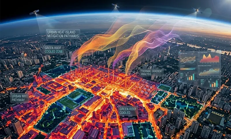
The Urban Heat Island (UHI) effect occurs when cities replace natural land cover with dense concentrations of pavement, buildings, and other surfaces that absorb and retain heat. This is measured via Land Surface Temperature (LST)—the “skin” temperature of the earth’s surface.
While daytime heat is often the focus of media attention, 2026 research has identified nocturnal LST as the primary driver of heat-related mortality. In a healthy ecosystem, the environment cools rapidly after sunset. However, the high thermal mass of concrete and asphalt acts as a battery, discharging heat throughout the night. When cities fail to cool down, the human body cannot recover from daytime heat stress, leading to a spike in cardiovascular and respiratory failures. Satellite TIR provides the only scalable method for mapping this nocturnal “heat signature” across entire metropolitan regions.
The Thermal Sensor Landscape (2026 Edition)
The ability to mitigate heat is directly tied to the quality of the data. The current 2026 satellite landscape offers unprecedented thermal fidelity:
- NASA’s ECOSTRESS: Operating from the International Space Station, ECOSTRESS provides high-spatial-resolution thermal data at varying times of day. This is critical for understanding the “Diurnal Cycle”—how different neighborhoods heat up and cool down over a 24-hour period.
- Landsat-9 Next: This mission has refined the ability to separate Emissivity from Kinetic Temperature. Because different materials (brick vs. asphalt vs. grass) emit thermal radiation differently, multi-spectral TIR sensors are required to calculate the true temperature of the surface accurately.
The physical foundation of this sensing is the Stefan-Boltzmann Law, which relates the total energy radiated per unit surface area ($j^*$) to the absolute temperature ($T$):
$$j^* = \epsilon \sigma T^4$$
Where $\epsilon$ is the emissivity of the surface and $\sigma$ is the Stefan-Boltzmann constant. By measuring $j^*$, satellites can back-calculate the surface temperature $T$ with remarkable precision.
Data Fusion and Downscaling: The 10-Meter Imperative
A major hurdle in urban planning has been the “resolution gap.” Traditional thermal satellites like MODIS provide data at a $1\ km$ resolution—far too coarse for street-level intervention.
In 2026, the standard practice is Data Fusion. Using Convolutional Neural Networks (CNNs), analysts fuse the high-frequency temporal data of MODIS with the high-spatial-resolution ($10\ m$ to $30\ m$) of Sentinel-2 and Landsat. This “downscaling” allows planners to see exactly which city blocks are overheating, identifying “micro-heat islands” that might be caused by a single unshaded parking lot or a specific industrial roof.
Strategic Mitigation Applications
Satellite TIR data is now the primary driver for three major cooling strategies:
- Biophilic Infrastructure: TIR imaging proves the “Transpirational Cooling” effect of urban forests. Vegetation doesn’t just provide shade; it actively cools the air as water evaporates from leaves. Satellites can quantify the exact degree reduction provided by a new park, helping to justify the ROI of green infrastructure.
- Albedo Management: By mapping the highest LST areas, cities can identify “Super-Emitters” for cool pavement programs. Applying high-albedo (reflective) coatings to streets can reduce surface temperatures by up to $10\text{°C}$ to $15\text{°C}$ during peak sun.
- Ventilation Corridors: Thermal gradients mapped from space reveal how heat “pools” in certain areas. Planners use this to design “wind paths”—aligning new developments to allow cool air from nearby water bodies or rural areas to flow through urban canyons.
The Role of Cloud Analytics and Social Equity
Platforms like Google Earth Engine (GEE) have democratized this data. Small and mid-sized cities no longer need massive on-site servers to process petabytes of satellite imagery.
More importantly, 2026 has seen the rise of Heat Vulnerability Indices (HVI). By overlaying LST maps with socio-economic data (such as age, income, and housing quality), cities can identify “Thermal Inequity.” This ensures that cooling resources—like misting stations or tree-planting initiatives—are prioritized for the neighborhoods that lack the financial means to run air conditioning.
Challenges: The Cloud and the Canyon
Despite these advances, satellite TIR faces two persistent physical limitations:
- Cloud Interference: TIR sensors cannot see through clouds. While SAR (Radar) can see through clouds, it does not measure temperature. This requires “gap-filling” algorithms that use weather station data to estimate LST on cloudy days.
- The Urban Canyon Effect: Satellites look straight down (nadir). In dense cities like New York or Tokyo, much of the heat is trapped on the vertical walls of skyscrapers, which are invisible to the satellite. To solve this, 2026 models integrate satellite data with drone-based thermal sweeps to create 3D thermal models of city centers.
From Monitoring to Action
The era of “admiring the problem” is over. In 2026, satellite thermal imaging has moved from the research lab to the city hall. It is influencing building codes—where new developments must meet “Thermal Neutrality”—and zoning laws that mandate minimum green-space ratios. By making the invisible threat of urban heat visible, we are building the foundation for the “Thermally-Aware City”—a metropolis that remains livable even in the face of a warming planet.
Comparison: Daytime vs. Nighttime Thermal Analysis
| Feature | Daytime LST Analysis | Nighttime LST Analysis |
| Primary Driver | Solar Radiation (Albedo) | Thermal Inertia (Material Mass) |
| Key Indicator | Surface Reflectivity | Heat Retention & Discharge |
| Health Focus | Heat Stroke / Acute Stress | Sleep Disruption / Recovery Failure |
| Mitigation Goal | Shade & Reflection | Ventilation & Heat Dissipation |
| Optimal Sensor | High Spatial ($10\ m – 30\ m$) | High Temporal (Revisit Frequency) |
| Policy Impact | Cool Roofs / Tree Canopy | Ventilation Corridors / Building Spacing |
