
The global agricultural insurance market is undergoing a structural transformation. As climate volatility renders traditional indemnity-based models economically unviable, “top-down” satellite monitoring has emerged as the foundational technology for the next generation of parametric insurance. By leveraging high-revisit orbital constellations and advanced vegetation indices, insurers can now offer automated, low-latency coverage that protects food security and financial stability in an increasingly unpredictable climate.
The Vulnerability of Global Food Systems
The traditional agricultural insurance model is at a breaking point. Under the “Indemnity-Based” system, a farmer suffers a loss, files a claim, and waits for a human loss adjuster to physically visit the field to verify the damage. In a year of widespread drought or catastrophic flooding, this process is agonizingly slow, prone to human error, and prohibitively expensive for insurers to administer.
Furthermore, as climate-induced crop failures become more frequent and severe, the administrative overhead of manual adjustment is making insurance premiums unaffordable for many, particularly in emerging markets. To maintain a resilient global food system, the industry is shifting toward a model where data, rather than physical inspection, dictates the flow of capital.
The Rise of Parametric Insurance
The solution lies in Parametric (Index-based) Insurance. Unlike traditional insurance that pays out based on an assessment of the actual loss, parametric insurance pays out a pre-defined amount when a specific “trigger” is met.
In this ecosystem, satellites serve as the ultimate “Oracles.” They provide objective, third-party data that can trigger automatic payouts. If a satellite detects that the soil moisture in a specific district has dropped below a set threshold for fifteen consecutive days, the insurance contract triggers a payout immediately. There is no claim to file and no adjuster to wait for. For the farmer, this means receiving liquidity exactly when it is needed—to buy replanting seeds or livestock feed—rather than months after the crisis has passed.
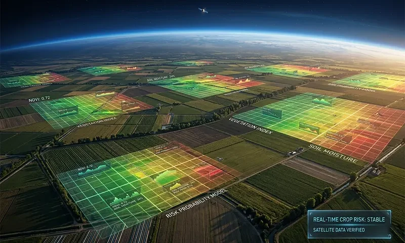
Technical Indicators for Crop Health
Modern satellite analysis has moved far beyond simple photography. Insurers now utilize a suite of sophisticated biological and physical indicators:
NDVI and EVI: The Biomass Benchmarks
The Normalized Difference Vegetation Index (NDVI) remains the workhorse of the industry. By measuring the contrast between red light (which plants absorb) and near-infrared light (which they reflect), NDVI provides a proxy for chlorophyll activity and biomass. The Enhanced Vegetation Index (EVI) is often used alongside it to correct for atmospheric “noise” and soil variations, providing a clearer picture of crop health in densely forested or high-canopy areas.
Synthetic Aperture Radar (SAR): Seeing Through the Clouds
Optical sensors are useless if a region is covered by clouds for three weeks during a monsoon. This is where SAR is revolutionary. Because SAR uses radar pulses that penetrate clouds, smoke, and darkness, it can measure soil moisture and crop structure regardless of weather conditions. This ensures that a “Flash Flood” event is captured and logged the moment it occurs.
Solar-Induced Fluorescence (SIF): The Early Warning System
The “Gold Standard” emerging in 2026 is SIF. When plants photosynthesize, they emit a tiny amount of light (fluorescence) that is invisible to the human eye but detectable by high-resolution spectrometers. Changes in SIF occur before a plant turns yellow or wilts. This allows insurers and farmers to detect “invisible” stress, such as the early stages of a drought, days or weeks before traditional optical sensors would flag a problem.
The Underwriting Revolution
Satellites have not only changed how we pay for losses but how we price them. Insurers now have access to over 20 years of historical satellite archives (from missions like Landsat and Sentinel), allowing them to build hyper-local baselines.
This wealth of data helps solve Basis Risk—the primary challenge of parametric insurance where the payout doesn’t perfectly match the actual loss on the ground. By using high-resolution data (down to 3-meter or even sub-meter resolution), insurers can distinguish between a farmer whose crop failed due to regional drought (an insurable climate risk) and one whose crop failed due to poor local management (a non-insurable risk).
Operational Benefits for Insurers
For the insurance industry, the transition to satellite-based monitoring offers a radical reduction in Operating Expenses (OpEx).
- Eliminating Moral Hazard: Because the data comes from a neutral orbital platform, it is impossible for a policyholder to “fake” a loss or for an adjuster to show bias. This integrity is vital for the “reinsurance” markets that back local insurers.
- Scalability: A single data scientist in an office in London or Singapore can monitor 10 million hectares of farmland across sub-Saharan Africa or Southeast Asia with the same precision as a local field office.
- Smart Contracts: When satellite data is fed into blockchain-based smart contracts, the entire insurance lifecycle becomes autonomous. This reduces the time-to-payout from 60–90 days to less than 72 hours.
Challenges to Scaling
Despite the technological leaps, several hurdles remain:
- Mixed Cropping: In many developing regions, farmers grow multiple crops in the same small plot. Distinguishing the “health signature” of maize from the beans growing beneath it requires extreme spectral and spatial resolution.
- Revisit Frequency: To catch a pest outbreak that can destroy a crop in 48 hours, insurers need daily “revisits.” While the growth of small-sat constellations (CubeSats) is solving this, the cost of high-frequency data is still a factor in premium pricing.
Toward a Resilient Frontier
The convergence of AI and orbital sensing is creating a safety net that was previously unimaginable. By 2026, we are seeing the integration of satellite data with local IoT weather stations to create a “Fused Truth” that is nearly irrefutable.
As climate change increases the “uninsurable” portions of the globe, satellite-backed parametric models provide the only viable path forward. They offer a rare win-win: insurers reduce their overhead and fraud risk, while the world’s most vulnerable food producers gain access to the rapid financial liquidity they need to survive a changing planet.
Technical Glossary
- NDVI (Normalized Difference Vegetation Index): A graphical indicator that uses the visible and near-infrared parts of the electromagnetic spectrum to analyze whether a target contains live green vegetation.
- SAR (Synthetic Aperture Radar): A form of radar that is used to create two-dimensional images or three-dimensional reconstructions of objects, such as landscapes. It can “see” through clouds and at night.
- Basis Risk: The risk that the insurance payout triggered by the index (e.g., satellite data) does not match the actual loss experienced by the farmer.
- Parametric Insurance: A type of insurance that does not indemnify the pure loss, but ex ante agrees to make a payment upon the occurrence of a triggering event.
- SIF (Solar-Induced Fluorescence): Light emitted by chlorophyll molecules during photosynthesis; used as a direct proxy for actual plant functional health.
