
Executive Summary: As global regulatory frameworks tighten and stakeholder demand for transparency peaks, the reliance on self-reported, “bottom-up” emissions estimates is no longer sufficient. High-resolution satellite monitoring is emerging as the ultimate “truth engine” in ESG reporting. By transitioning from theoretical calculations to direct orbital observations, corporations can identify super-emitters in real-time, mitigate Scope 3 risks, and provide investors with the high-fidelity data required to prove genuine decarbonization.
The Trust Gap: From Estimation to Observation
For decades, corporate greenhouse gas (GHG) reporting has been an exercise in accounting rather than measurement. Companies typically calculate their carbon footprint using “emission factors”—multiplying activity data (like fuel consumed) by a theoretical average of emissions produced. While useful, this “bottom-up” approach is prone to significant error, often missing fugitive emissions or equipment malfunctions that can lead to massive, unreported leaks.
This has created a significant Trust Gap. Investors and regulators are increasingly skeptical of sustainability reports that lack independent verification. High-resolution satellite monitoring is bridging this gap by providing a “top-down” view. Instead of guessing what a facility should be emitting, satellites see what it is emitting, turning climate action from a paperwork exercise into a verifiable reality.
The Technology Shift: Seeing the Invisible
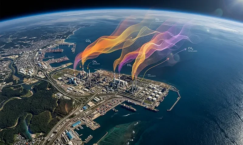
The breakthrough in satellite monitoring lies in the evolution of hyperspectral imaging and the refinement of spatial resolution. Historically, satellites like Landsat provided broad views of the Earth’s surface, but they lacked the precision to pinpoint specific industrial leaks.
Modern constellations now utilize advanced spectrometers that analyze the “fingerprints” of light. Every gas, including Carbon Dioxide ($CO_2$) and Methane ($CH_4$), absorbs light at specific wavelengths. High-resolution sensors can now detect these spectral signatures at a sub-100-meter resolution, allowing them to:
- Pinpoint Point Sources: Differentiating between a single leaking valve at an oil refinery and the general background emissions of a city.
- Quantify Flux: Calculating the mass flow rate of a plume to determine exactly how many kilograms of gas are escaping per hour.
- Multi-Gas Tracking: While $CO_2$ is the primary target for long-term climate goals, satellites have become exceptionally proficient at tracking $CH_4$, which has over 80 times the warming power of $CO_2$ over a 20-year period.
Corporate Applications: Operational and Supply Chain Clarity
The integration of orbital data into corporate strategy offers three primary avenues for value creation:
1. Direct Operations and Asset Management
For heavy industry, oil and gas, and mining, “super-emitters”—single sources responsible for a disproportionate amount of total emissions—are a major liability. High-resolution monitoring allows operators to detect leaks in remote pipelines or offshore rigs that ground-based crews might not visit for months. This enables Direct Directed Inspection and Maintenance (DI&M), saving product (in the case of natural gas) and reducing environmental impact simultaneously.
2. Scope 3 and Supply Chain Integrity
The most difficult challenge for any Sustainability Officer is Scope 3 emissions—those occurring in the value chain. Satellites allow companies to monitor the environmental performance of their suppliers in real-time. For example, a consumer goods company can use satellite imagery to verify that its palm oil suppliers are not engaging in illegal land clearing (which releases massive amounts of sequestered carbon) or monitor the methane intensity of the dairy farms in its supply chain.
3. Audit-Ready ESG Reporting
As the International Sustainability Standards Board (ISSB) and other regulatory bodies move toward mandatory climate disclosures, “reasonable assurance” becomes the standard. Satellite data provides an immutable, third-party data layer that can be audited, reducing the legal and reputational risk of accidental misreporting.
The Competitive Advantage: Attracting Green Capital
In the modern capital market, data is the primary currency. Investors are moving away from broad ESG scores toward Climate Intelligence. Companies that proactively integrate satellite monitoring into their disclosures gain a distinct competitive edge:
- Access to Sustainable Finance: Lenders are increasingly offering lower interest rates to companies that can prove their emissions reductions with hard data.
- Radical Transparency: By “beating” third-party activists to the punch and reporting their own leaks first, companies maintain control of their narrative and demonstrate a commitment to honesty that builds brand equity.
- Avoiding Greenwashing: With organizations like Climate TRACE and various NGOs using satellites to “police” the planet, corporations that rely on faulty estimates risk public exposure. Using the same high-resolution tools internally ensures there are no “surprises” for the C-suite.
Challenges: The Limits of the Eye in the Sky
Despite its potential, satellite monitoring is not a silver bullet. Several hurdles remain:
- Temporal Resolution: A satellite might only pass over a specific facility once every few days. If a leak occurs between passes, it might be missed. This is being addressed by launching “constellations” of many small satellites to increase revisit frequency.
- Cloud Cover and Interference: Optical and hyperspectral sensors cannot see through heavy cloud cover or thick smoke. This necessitates Data Fusion—the practice of combining satellite observations with ground-based IoT sensors and flyover data to create a continuous monitoring loop.
- Data Processing: The sheer volume of hyperspectral data is staggering. Raw data from orbit is not immediately useful; it requires complex atmospheric correction and physics-based modeling to convert a “glimmer” on a sensor into a tonnage of $CO_2$.
The Future Outlook: AI and Orbital Accountability
The future of corporate emissions monitoring lies in the marriage of Orbital Sensing and Artificial Intelligence. AI algorithms are now capable of scanning thousands of square kilometers of satellite imagery to automatically detect and flag methane plumes without human intervention. This “automated alerting” system will soon become standard for industrial giants.
Furthermore, as the cost of launching “CubeSats” continues to fall, we are entering an era of persistent surveillance. Within this decade, it will be virtually impossible for any significant industrial emission source on Earth to remain hidden.
High-resolution satellite monitoring is transforming greenhouse gas emissions from an abstract accounting problem into a visible, manageable operational metric. For corporations, the message is clear: the era of “estimate and pray” is over. Those who embrace orbital transparency will find themselves better equipped to manage risk, satisfy investors, and lead the transition to a low-carbon economy. In the race to Net Zero, the best view is from 500 kilometers up.
